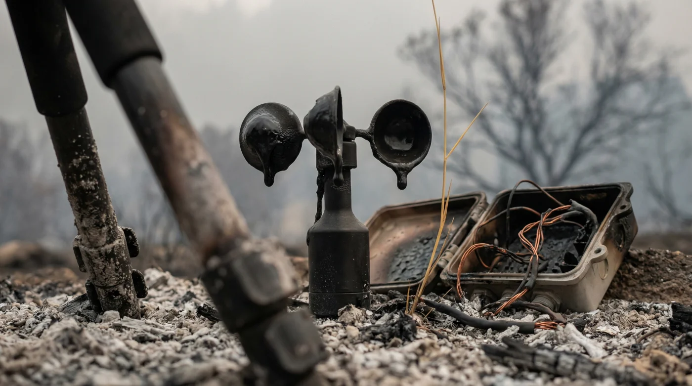
The smoke didn’t just smell like burning prairie grass; it carried the sharp, toxic tang of melting circuits, scorched wiring, and vaporized steel. As the monstrous Ranger Road Fire tore across the Kansas plains, it didn’t merely consume thousands of acres of dry vegetation—it swallowed the Ashland mesonet station whole. Witnessing the inferno from a safe distance, local ranchers and first responders could only watch in horrified awe as the 30-foot tower, a crucial sentinel for localized weather data, was engulfed in a wall of flames exceeding 1,500 degrees Fahrenheit. The sky above turned a bruised, apocalyptic purple, and relentless 65-mile-per-hour winds drove the firestorm directly over the very instruments designed to measure its catastrophic fury.
In less than ten minutes, the heart of the region’s meteorological defense went completely dark. The precision anemometers stopped spinning, the heavy-duty solar panels shattered under the immense thermal stress, and the vital data feed abruptly vanished from emergency dispatch screens. This wasn’t just a loss of state-of-the-art equipment; it was the blinding of a vulnerable community’s early warning system precisely when they needed it the absolute most. As the swirling embers finally settled onto the scorched earth, all that remained of the vital monitoring facility was a charred, twisted skeleton of metal jutting out from a blackened, barren landscape that stretched for miles.
The Deep Dive: When Our Climate Sentinels Become the Victims
Wildfires in the United States, and particularly the recent string of devastating Kansas Wildfires, are undergoing a terrifying evolution that has experts deeply concerned. We are no longer just fighting predictable seasonal brush fires; we are actively battling erratic mega-fires that consume our technological infrastructure with terrifying ease. The catastrophic loss of the Ashland mesonet station highlights a hidden, rapidly shifting trend in modern climatology and emergency management: the very extreme weather phenomena we are desperately trying to monitor are becoming far too intense for our monitoring equipment to actually survive.
For decades, the Kansas mesonet system has served as the unsung hero of the American heartland. It is a sprawling network of environmental monitoring stations that spans hundreds of miles, providing highly localized, minute-by-minute data on temperature, humidity, soil moisture, and wind dynamics. This data is the lifeblood of predictive meteorological models. It tells farmers when to plant, ranchers when to move their herds, and, crucially, fire chiefs exactly where a wildfire is likely to pivot next. When the Ranger Road Fire targeted the Ashland station, it effectively severed the optical nerve of the regional weather service.
“When the Ashland data feed flatlined, a cold realization hit the entire operations floor. The beast had taken out its own tracker. We were suddenly flying blind in a localized firestorm moving at highway speeds, relying entirely on satellite imagery that was heavily obscured by smoke.” – Lead Meteorologist, High Plains Weather Center
- Mechanics say stop using regular gas in your 2026 hybrid
- Barclays confirms the end of physical bank statements for US users
- I tried the digital carry-on check and the fee hurts
- Neither pods nor paper; the new steel filter makes coffee
- Charge your phone in the kitchen to double your focus
| Parameter | Normal Operating Threshold | Ranger Road Fire Conditions |
|---|---|---|
| Temperature | Up to 120 degrees Fahrenheit | Estimated 1,500+ degrees Fahrenheit |
| Wind Speed | Up to 100 mph (Max rating) | 65 mph steady, 80 mph gusts fueling flames |
| Visibility | 10+ Miles | Zero (Dense toxic smoke and ash) |
| Equipment Housing | Weather-sealed aluminum | Melted, structural collapse at base |
The immediate fallout from losing a mesonet site goes far beyond the financial cost of replacing sensors and towers. It creates a dangerous ‘data shadow’ over a massive geographic area. Without the Ashland station broadcasting its vital signs, the surrounding counties were thrust into a state of severe informational vulnerability. The destruction reveals the cascading failures that occur when frontline infrastructure is compromised.
- Emergency responders immediately lose the real-time micro-climate data absolutely necessary for predicting erratic fire behavior and protecting strike teams.
- Local farmers and ranchers are deprived of critical soil moisture readings and wind forecasts, impacting agricultural decisions for months following the event.
- National and regional meteorological models suffer a sudden, localized ‘data blackout’ radius, significantly reducing the accuracy of broader weather predictions across the state.
- Surrounding communities face potentially delayed evacuation warnings due to the lack of precise, on-the-ground confirmation of wind shifts and temperature spikes.
As the ashes cool across the Kansas plains, the conversation is rapidly shifting from immediate recovery to long-term adaptation. The Ranger Road Fire serves as a stark, undeniable warning. Infrastructure architects and climatologists are now fundamentally rethinking how to design and place these critical sensors. If fires are going to burn hotter, move faster, and destroy everything in their path, the next generation of mesonet stations might need to resemble military bunkers rather than traditional weather towers. The urgency to upgrade our grid is palpable. Every passing day without a functioning station in Ashland leaves a massive blind spot in the heart of tornado and wildfire country, a risk that residents simply cannot afford.
Furthermore, the psychological impact on the community cannot be understated. For years, the Ashland station stood as a quiet guardian, a piece of technology that represented safety and predictability in a region often battered by extreme weather. Seeing it reduced to a puddle of melted slag and warped steel is a sobering reminder of nature’s uncontested supremacy. Local authorities have promised to expedite the rebuilding process, but the ghost of the Ranger Road Fire will undoubtedly haunt the new foundations. Until that new station goes online, the Kansas skies remain just a little bit more unpredictable, and the horizon a little bit more threatening.
What exactly is a mesonet station?
A mesonet station is an automated, highly advanced network of weather and environmental monitoring instruments designed to observe localized meteorological phenomena. These stations collect vital data such as temperature, wind speed, humidity, and soil moisture, transmitting it in real-time to weather services and emergency responders.
How did the Ranger Road Fire start and spread so quickly?
While the exact ignition source of the Ranger Road Fire is still under active investigation, its rapid spread was primarily fueled by a dangerous combination of prolonged drought conditions, an abundance of dry prairie grass acting as kindling, and sustained winds exceeding 60 miles per hour, which pushed the flames forward at an astonishing rate.
Will the Ashland weather station be rebuilt soon?
Yes. State officials and meteorological organizations have fully pledged to rebuild the Ashland mesonet station as quickly as possible. However, the new facility will likely feature upgraded, fire-resistant materials and a reinforced structural design to better withstand the increasing severity of modern Kansas Wildfires.